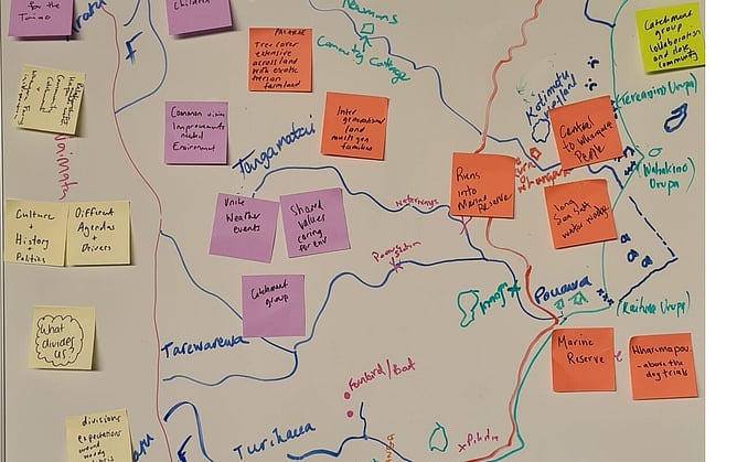
Whenua mapping is one of the simplest activities used in AraHina’s workshops, yet it often becomes one of the most powerful.
It has proven to be an effective way to bring together fifth generation farmers and tangata whenua in a way that honours everyone’s whakapapa, history, and connection to place.
By grounding conversations in the land itself, relationships can begin from a place of shared understanding.
Beginning With Connection to Place
The activity usually begins in a light-hearted way.
Participants are invited to place themselves on a map of the whenua as they arrive at the workshop.
At first, it simply allows people to identify where they live or where they come from.
But as the workshop progresses, the activity naturally deepens.
Participants begin sharing stories connected to the land, discussing significant locations, and reflecting on their relationships to the area.
Through this process, whakapapa, shared history, and sites of importance begin to surface.
Grounding the conversation in place from the beginning helps create a foundation for meaningful discussion and stronger relationships.
What the Process Reveals
What has been most surprising is the impact that this simple activity can have beyond the workshop itself.
Whenua mapping has helped groups develop a deeper understanding of Māori sites of significance.
Stories connected to Māori place names have revealed historical information about the landscape. In some cases, these insights have even helped identify original inanga (whitebait) spawning habitats.
In other situations, the stories attached to place names have helped communities track ecological changes in the land and support scientific understanding of land production.
These insights show how mātauranga Māori can complement modern environmental knowledge.
The Rise of Cultural Mapping
Another outcome emerging from these workshops is a growing interest in cultural mapping.
On a smaller scale, farmers, schools, and tangata whenua have begun placing signs at sites of cultural and historical significance.
On a wider scale, farmers, councils, tangata whenua, and geospatial specialists have begun working together to formally map cultural sites using modern mapping technology.
This approach brings together Indigenous knowledge and contemporary tools to help protect the whenua and guide future land use decisions.
Walking the Whenua
A powerful example of this work can be seen at Whāngārā Farms.
There, teams are physically walking the land to verify cultural sites, connect mātauranga Māori with biodiversity knowledge, and support land management decisions that protect both whakapapa and the environment.
This work is being led by Matire Kupenga-Wanoa and the wider team, demonstrating what collaborative, mana-enhancing partnerships can look like when the foundations are built with care.
Building Authentic Partnerships
Working alongside tangata whenua and farmers in rural communities is both a strength and a passion of AraHina’s work.
When relationships are grounded in respect for whakapapa, shared history, and connection to whenua, communities can move forward together in ways that benefit both people and place.
These kinds of partnerships create the conditions for lasting change.
And sometimes, all it takes to begin that process is something as simple as placing a map on the wall.

